Traffic Impacts
May 2026 Update
Bridge construction has begun with the early activities focused at Flying Horse Club Drive and work at Ridgeline Drive to follow later in June. Utility relocations continue, and intermittent lane shifts are expected. Please follow all posted signage and drive safely in work zones. In early to mid-June, a detour at Flying Horse Club Drive will go into effect. More information will be posted as it becomes available. Explore more information about the project in the tabbed section below and stay informed by signing up for project news.
Please note that the Temple project at Flying Horse Club Drive is privately managed and not associated with the City’s project. Intermittent impacts associated with this project are expected over the next several months.
Text POWERS to 21000 to receive text alerts regarding construction updates and traffic impacts.
About
The Powers Boulevard Extension is a long-planned regional transportation improvement that will expand northward from Highway 83 to Voyager Parkway. This critical corridor will improve mobility, reduce congestion, and better connect northeast Colorado Springs with I-25 and surrounding communities.
Led by the City of Colorado Springs in coordination with Copper Ridge Metropolitan District and CDOT, the project is progressing ahead of the city’s typical schedule, thanks to proactive funding strategies and regional collaboration.
Roadway Improvements
The Powers Boulevard Extension will be designed as an expressway, consistent with the existing segment between Research Parkway and Old Ranch Road. Key features include:
- A new interchange at Highway 83
- An overpass over Black Squirrel Creek
- Underpasses beneath Ridgeline Drive and Flying Horse Club Drive
- An overpass at Old Northgate Road
- Limited access points at Voyager Parkway and Highway 83 to support efficient traffic flow
The concept design and alignment for the extension were approved in 1997, prior to development of the Flying Horse and Northgate communities. The extension will be configured similarly to the existing Powers Boulevard expressway between Research Parkway and Old Ranch Road.
Preliminary engineering is complete, with final engineering anticipated to continue in 2026. Early construction activities, including utility relocations and construction of local bridges, are planned to begin in 2026, with phased roadway construction expected to continue through at least 2030. The entity responsible for future construction, whether a developer or the City of Colorado Springs, has not yet been finalized. All work is overseen by the City of Colorado Springs and the CDOT.
Noise Study
As part of the roadway design and environmental analysis process, a noise analysis is underway. An open house was held July 17, 2025, to explain the noise analysis process. Click on the Public Engagement tab to see the video and the presentation boards from that meeting. More details about the noise analysis process will be published as they become available.
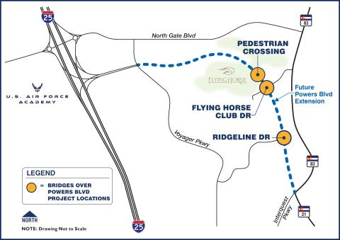
Bridges
In early 2026, construction will begin on three new bridges at Flying Horse Club Drive, Ridgeline Drive, and a new pedestrian bridge north of Flying Horse Club Drive. Flying Horse Club Drive will remain open during construction, with a two-way traffic detour available. Ridgeline Drive will be closed during construction; additional details and advance notice will be provided as the closure date approaches.
In late 2023, Voyager Parkway was closed to allow construction of the Voyager Bridge, which carries local traffic over the future Powers Boulevard. This early investment minimized long-term disruption and supports efficient delivery of the corridor. The bridge was completed and reopened to traffic in 2024. Construction was led by the Copper Ridge Metropolitan District, and the bridge connects directly to the recently completed I-25/Powers Boulevard Interchange at Exit 155.
Work receives oversight from the City of Colorado Springs and CDOT.
Funding
In November 2022, the Powers Boulevard Extension (from SH-83 to Voyager Parkway) was approved as a PPRTA A-list project, prioritizing it for voter-approved regional transportation funding.
To accelerate construction, the Copper Ridge Metropolitan District advanced the Voyager Parkway Bridge ahead of PPRTA fund availability. This proactive move supports nearby development and reduces traffic impacts before the main Powers Boulevard extension begins.
To accelerate construction and advance the project efficiently, the Copper Ridge Metropolitan District is providing upfront funding and will be reimbursed with PPRTA funds.
Public Engagement
Bridge Construction Open House - January 28, 2026
Click below to review meeting materials:
Noise Analysis Open House - July 17, 2025
The City held an open house about the project's noise analysis study on July 17, 2025, 5:30 - 7 p.m. at Discovery Canyon High School. Meeting materials are available below.
Project Timeline
- 1963: Powers Blvd added to Major Thoroughfare Plan
- 1996-1997: Environmental Assessment
- 1998: NEPA Decision and “Date of Public Knowledge”
- 2021: Powers Blvd and I-25 Interchange completed
- 2024: Voyager Bridge completed
- 2025: Noise Analysis started
- 2026: Noise Analysis continues, local bridge construction begins
- 2027-2030: Roadway (mainline) construction
Frequently Asked Questions
Why now?
Although Powers Boulevard has been in the works for decades, this extension of the corridor hasn’t been built yet; however, public knowledge of this corridor was officially established in 1998. As final design progresses, an updated noise study is required to evaluate future impacts using the most current data and methods.
Is construction starting soon?
Bridge construction is anticipated to begin early 2026. Waterline relocation construction is under contract and is anticipated to begin in early February. This utility relocation is a precursor to bridge construction. Powers Blvd roadway construction will happen in later phases.
Will noise be analyzed after the roadway is built?
Post-construction noise analysis is not anticipated.
How is roadway elevation determined?
The roadway location and elevation (profile) was determined in previous project phases based upon engineering considerations such as drainage, safety, and existing topography. Current and future project phases will not include any modifications to the established roadway profile.
How is speed limit determined?
Speed limits are determined based on federal, state, and local design standards for established road classifications and location context. The speed limit for each classification informs the design requirements to ensure traffic safety and operation. Powers Blvd is classified as a freeway.
How are traffic volumes projected?
Traffic volume forecasts are prepared using regional travel models to account for future growth. The design accounts for both current traffic volumes and projected 2050 traffic volumes.
Will Flying Horse Club Drive be closed during construction?
Flying Horse Club Drive will remain open through the duration of construction with one lane in each direction. The traffic will be shifted during different construction phases but will always remain open to traffic.
Will Ridgeline Drive be closed during construction?
Ridgeline Drive will be closed for the duration of the bridge construction at that location.
Will my utilities be shut off?
Utilities are being relocated for the project, but service interruptions are not anticipated. If the need for short-term disruptions in service arise during the project, this will be communicated to residents with advance notice.
What is the noise study about?
The City of Colorado Springs is studying traffic noise along the Powers Boulevard Extension to understand how the future roadway may impact nearby neighborhoods and properties. The study is part of a federally required environmental evaluation process. For more information, click here to review a white paper about the noise study.
What is the “date of public knowledge”?
This refers to the date when a formal federal decision was made about the original Powers Boulevard corridor. In this case, that date is January 1998. Any development approved after that date is subject to the understanding that funding for noise mitigation may not apply (e.g., developments within Flying Horse).
Flying Horse was annexed on Oct. 28, 2003 (meaning brought into the city limits), after the date of public knowledge.
Powers Boulevard has always been included in all development plans for the area, including Flying Horse, and land (right of way) has been preserved for future highway construction.
Does the noise study decide if mitigation will happen?
The study identifies potential impacts based on noise thresholds. If impacts are found, the next step is to determine if mitigation is both feasible (it works) and reasonable (cost-effective and supported by residents) under Colorado Department of Transportation (CDOT) and Federal Highway Administration (FHWA) criteria.
IF it qualifies, nearby property owners would be contacted during a future phase to gather input before any decisions are made.
Potential mitigation strategies, if warranted and approved, could include physical measures such as landscaped berms or other sound-reducing features, depending on the unique conditions of the area.
How will potentially affected residents be notified about noise study findings?
A 500-foot buffer from the future travelway edge defines the “study area.” Within this zone, “noise-sensitive receptors”—places like homes, schools, parks, and churches— are analyzed using 3D noise modeling. The model factors in:
- Projected traffic volumes and speeds
- Roadway design (including bridges, cut/fill, barriers, etc.)
- Topography and ground type
- Existing structures like buildings or walls that could reflect or block sound
What happens if a noise impact is identified?
If noise levels meet federal impact thresholds (66 dB or a 10 dB increase), then mitigation will be considered.
Considered mitigation strategies must meet the following criteria to continue in the evaluation:
- Reduce noise by at least 5 dB for 3+ properties and confirm buildability of potential mitigation from a design and construction standpoint (feasibility)
- Reduce by 7 dB for 2+ properties, be cost-effective, and have majority support from those who would benefit—based on noise computer model results—from the strategy (reasonableness)
IF those criteria are met, CDOT and FHWA must approve the solution. Then, and only then, would residents be surveyed. The survey would be sent only to those “noise sensitive” places (like homes, schools, parks, and churches) that would benefit from mitigation, based on the noise computer model results. In other words, not all community members within the 500 ft study area would receive a survey, IF a survey about potential mitigation is distributed.
Potential mitigation would be considered for implementation only if at least 51 percent of survey responses indicate support for the potential mitigation measure.
What’s considered “too loud”?
Imagine your home currently experiencing 56 dB of traffic noise. If future conditions would raise that to 66 dB or higher—or even to 66 from 56—that would trigger mitigation review. A 10 dB increase, even if under 66, would also qualify as an impact under federal rules.
Example: normal conversation is around 60 dB and the average gas lawnmower is between 85 and 100 dB.