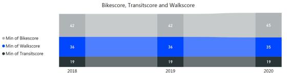
Improving walkability and throughout the city is a cornerstone goal of PlanCOS. Increasing bicycle infrastructure and safety is also a major objective, as is taking transit to the next level especially in key activity centers and corridors. Walkscore® and its related Bikescore® and Transitscore® are nationally recognized measures for walkability and bicycle and transit access, in communities. These scores can be calculated citywide, or for areas of focus, and can be compared with other communities. However, because these measures are primarily based on a calculation of land use proximity, and do not account for the quality and design of walkable infrastructure, care should be taken in interpreting the results. This indicator can also be coupled with tracking the number of miles of bike lanes and bicycle infrastructure. These indicators are not available for years prior to 2018.
Walkscore®, Bikescore®, and Transitscore®
Goal: The goal of these indicators is to increase them.
Table: Dollars Spent on Park Operations per Person
| 2018 | 2019 | 2020 | |
|---|---|---|---|
| Walkscore | 36/100 | 36/100 | 35/100 |
| Bikescore | 42/100 | 42/100 | 45/100 |
| Transitscore | 19/100 | 19/100 | 19/100 |
Source: Walk Score
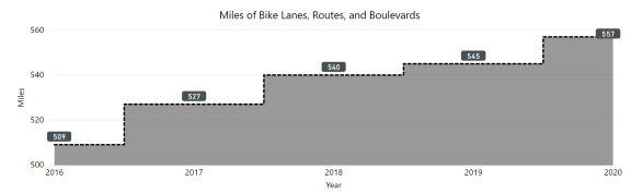
Miles of Bike Lanes, Routes and Boulevards
Goal: The goal is to increase the miles of bike Lanes, Routes and Boulevards.
Table: Miles of Bike Lanes, Routes and Boulevards
| 2017 | 2018 | 2019 | 2020 | |
|---|---|---|---|---|
| Bike Lanes | 226.6 | 244 | 246.6 | 253.6 |
| Bike Routes | 212.4 | 214 | 209.9 | 209.0 |
| Bike Boulevards | 3 | 3 | 3 | 3 |
| Buffered Bike Lanes | 7.7 | 16 | 20.6 | 22.8 |
| Shared Lane Marking | 2.3 | 5.7 | 5.7 | 5.7 |
| Protected Bike Lane | 0 | 0.6 | 0.6 | 0.6 |
| Contra-flow Bike Lane | 0.4 | 0.4 | 0.4 | 0.6 |
| Miles of Bike Lanes, Routes, and Blvds | 527.0 | 540.0 | 545.0 | 557.0 |
Source: Colorado Springs bike facility data, provided by Bike Plan